
3:46 pm monday 1/26/2026
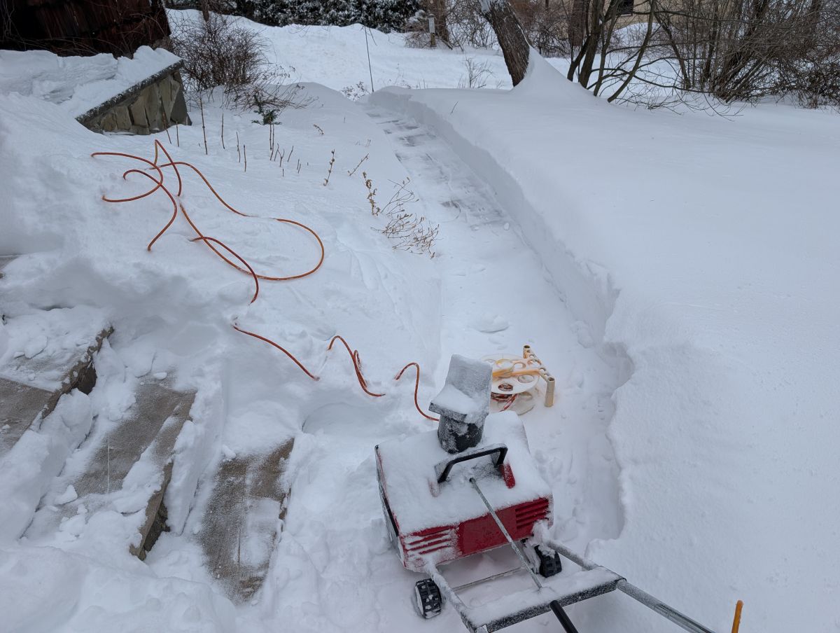
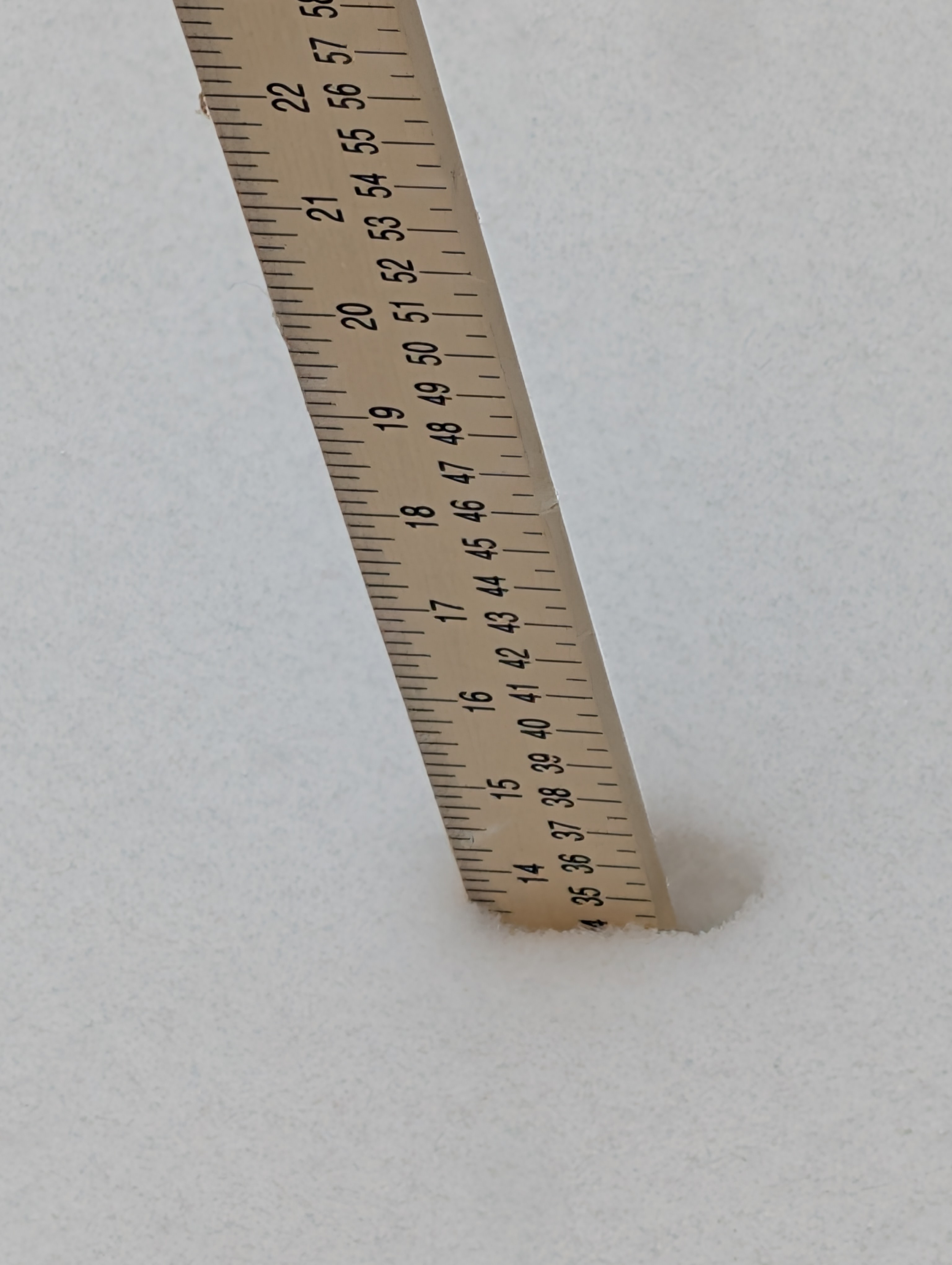
Winter Storm Fern has come and gone leaving behind seventeen inches of snow in lower West Milford N.J.. I got my SUV out of the driveway and took a victory lap around town only to find all the streets showing blacktop
10:37 am Monday 1/26/2026
The snow is falling again this morning, though thankfully, it appears to be a relatively light snowfall, and so far, it hasn’t caused any significant disruptions to our daily routines. While our driveway thankfully received a thorough plowing earlier, the cars are still partially buried, and the sidewalks and walkways around the house are in dire need of clearing. I am currently putting on my brave face and attempting to summon the motivation to head outside and tackle the snowy mess that awaits.
9:26 pm Monday 1/26/2026
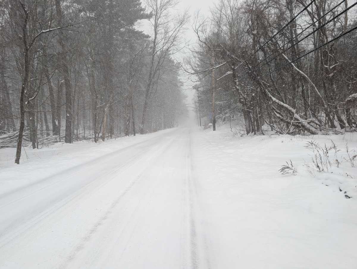
While the heavy snowfall of the recent winter storm seems to have finally abated, and thankfully, the local roads within our neighborhood are now passable, the situation on the county road leading out remains quite different. Specifically, the county road still bears a thick blanket of snow, with just a faint track suggesting where vehicles have managed to squeeze through. As a result of the persistent snow, our vehicles are currently entombed, and we anticipate a considerable effort will be required to excavate them. It’s worth noting, despite the general improvement, our driveway, unfortunately, has yet to receive any plowing services.
11:55 pm Sunday 1/25/2026
After what felt like an eternity of unrelenting snowfall, it appears the blizzard has finally subsided, offering a fragile sense of calm to our snow-laden surroundings. While there’s still a noticeable amount of wind-driven snow creating localized drifts, the most prominent activity outside my window is the steady, tireless work of plow trucks, the only vehicles venturing out amidst the remaining wintery conditions. Beyond the essential efforts to clear the roads, an unusual quiet has settled, a stark contrast to the chaos of the storm’s peak, allowing for a moment to appreciate the momentary peace.
updated: 835 PM EST Sun Jan 25 2026
…WINTER STORM WARNING REMAINS IN EFFECT UNTIL 1 PM EST MONDAY…
TONIGHT
Snow early this evening, then a chance of freezing rain and snow after midnight. Total snow accumulation of 12 to 16 inches. Additional ice accumulation around a trace. Lows around 13. Northeast winds 10 to 15 mph with gusts up to 25 mph. Chance of precipitation near 100 percent. Wind chill values as low as 3 below.
MONDAY
Mostly cloudy with a chance of light snow in the morning, then partly sunny in the afternoon. Highs in the mid 20s. Northwest winds 5 to 10 mph with gusts up to 25 mph. Chance of snow 40 percent.
7:47 pm Sunday 1/25/2026
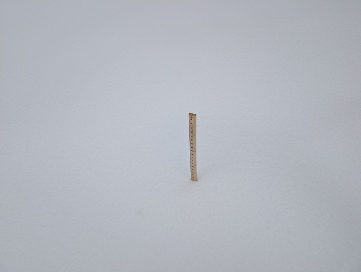
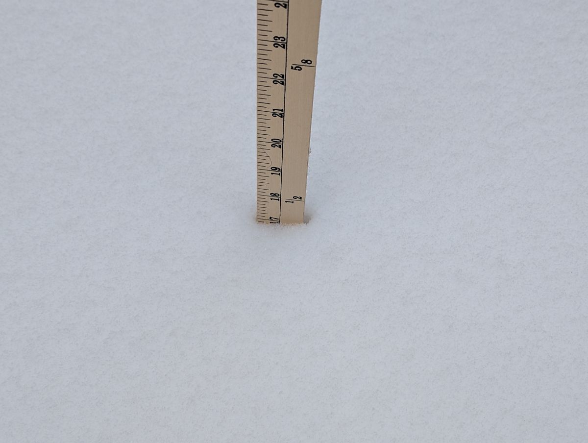
After braving the elements and returning from clearing snow from both of our cars, it’s become painfully evident that Mother Nature has no intention of slowing down. It appears as though we’ve received yet another foot of snow since the first snowfall this morning. Adding insult to injury, we just witnessed a county plow making its way up the street, but the relentless blizzard continues, with snow still falling heavily. We are measuring twenty inches of snow accumulation so far!
updated: 316 PM EST Sun Jan 25 2026
…WINTER STORM WARNING REMAINS IN EFFECT UNTIL 1 PM EST MONDAY…
TONIGHT
Snow, a slight chance of sleet and freezing rain this evening, then snow with a chance of freezing rain after midnight. Areas of blowing snow this evening with visibility one quarter mile or less at times. Snow and sleet accumulation of 1 to 3 inches. Ice accumulation around a trace. Lows around 15. Northeast winds 10 to 15 mph with gusts up to 25 mph. Chance of precipitation near 100 percent. Wind chill values as low as 2 below.
MONDAY
Mostly cloudy with a chance of light snow with a slight chance of light freezing rain in the morning, then partly sunny in the afternoon. Highs in the mid 20s. Northwest winds 5 to 10 mph with gusts up to 25 mph. Chance of precipitation 40 percent.
4:14 pm Sunday 1/25/26
It’s still snowing!!
rt23 staff
2:33 pm Sunday 1/25/26
Latest update:
updated: 1039 AM EST Sun Jan 25 2026
…WINTER STORM WARNING NOW IN EFFECT UNTIL 1 PM EST MONDAY…
TODAY
Snow, then snow and sleet this afternoon. Snow may be heavy at times. Snow and sleet accumulation of 4 to 8 inches. Cold with highs around 16. Northeast winds 5 to 10 mph. Gusts up to 25 mph this afternoon. Chance of precipitation near 100 percent. Wind chill values as low as 6 below.
TONIGHT
Snow and sleet, mainly in the evening. Total snow accumulation of 10 to 14 inches. Lows around 15. Northeast winds 10 to 15 mph with gusts up to 25 mph. Chance of precipitation near 100 percent.
MONDAY
Mostly cloudy with a chance of snow in the morning, then partly sunny in the afternoon. Highs in the upper 20s. Northwest winds 5 to 10 mph. Gusts up to 25 mph in the afternoon. Chance of snow 50 percent.
To ensure the safety and efficiency of our snow clearing operations, we have a strategy of working in short, focused bursts, interspersed with necessary rest periods. We proactively cleared our vehicles of snow and ice earlier today and will repeat this process again shortly, given the current forecast predicting freezing rain. This anticipated weather condition is expected to significantly increase the challenges and complexities associated with our snow removal tasks.
12:00 pm Sunday 1/25/2026
First Sighting: Passaic County snow plows have been spotted operating on Union Valley Road, also known as County Road 513, located in West Milford, New Jersey. The current road conditions are notably unfavorable, as the roadway is entirely blanketed by snow, with no asphalt surface visible.
updated: 1039 AM EST Sun Jan 25 2026
…WINTER STORM WARNING NOW IN EFFECT UNTIL 1 PM EST MONDAY…
TODAY
Snow, then snow and sleet this afternoon. Snow may be heavy at times. Snow and sleet accumulation of 4 to 8 inches. Cold with highs around 16. Northeast winds 5 to 10 mph. Gusts up to 25 mph this afternoon. Chance of precipitation near 100 percent. Wind chill values as low as 6 below.
TONIGHT
Snow and sleet, mainly in the evening. Total snow accumulation of 10 to 14 inches. Lows around 15. Northeast winds 10 to 15 mph with gusts up to 25 mph. Chance of precipitation near 100 percent.
MONDAY
Mostly cloudy with a chance of snow in the morning, then partly sunny in the afternoon. Highs in the upper 20s. Northwest winds 5 to 10 mph. Gusts up to 25 mph in the afternoon. Chance of snow 50 percent.
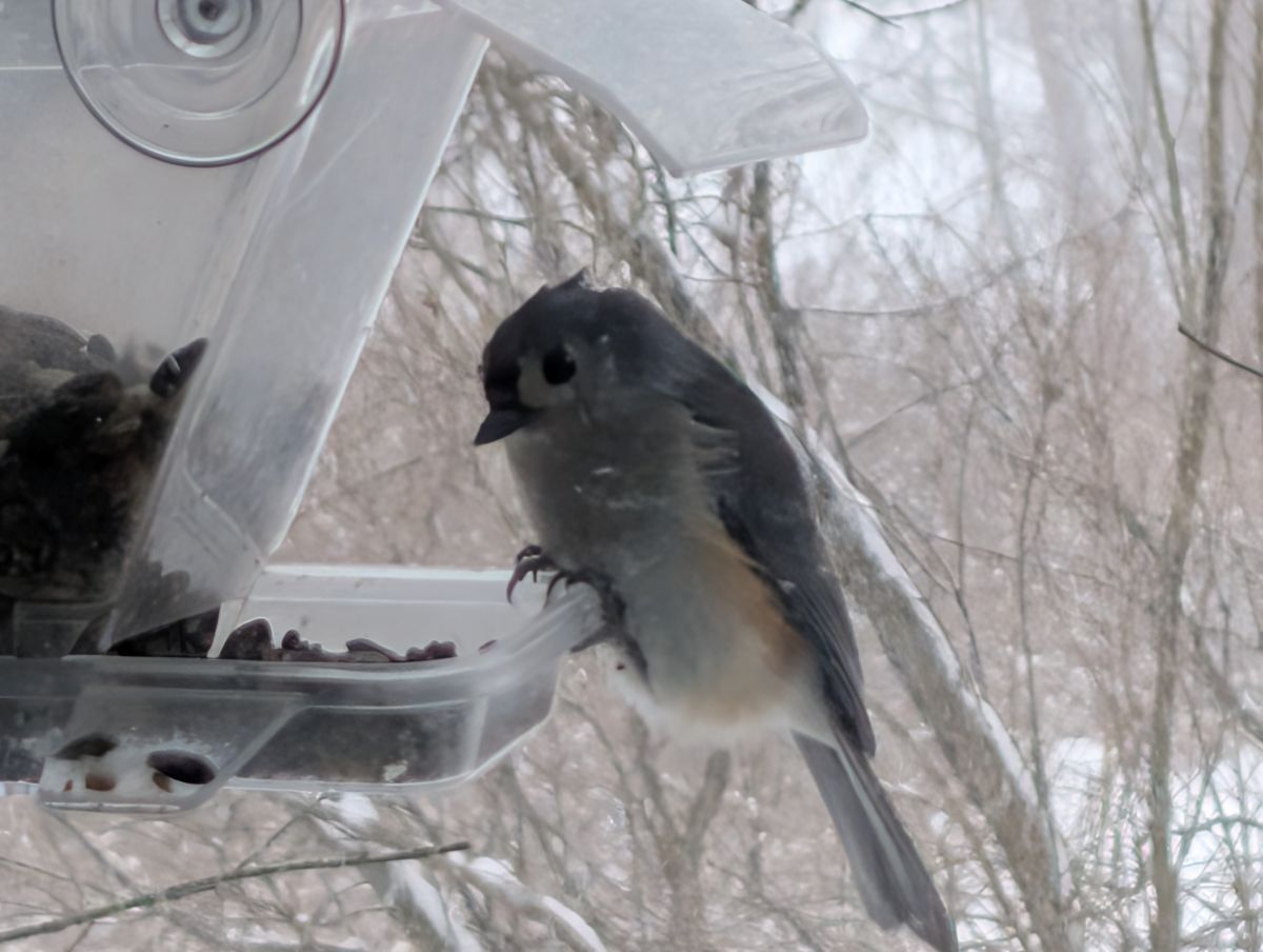
With the heavy snow blanketing our region, it’s become quite evident just how much our backyard bird feeders are appreciated. We’ve observed a significant increase in activity, with a diverse array of feathered friends making regular visits. The seed feeders are a bustling hub of activity, with cheerful chickadees, energetic tufted titmice, vibrant cardinals, and the characteristic slate-colored juncos, whom we affectionately call “snowbirds,” all eagerly participating in the feast. Meanwhile, our suet feeders have also become popular destinations, attracting the percussive presence of both red-bellied and downy woodpeckers, who are diligently searching for tasty treats amidst the snowy landscape.
9:33 am Sunday 1/25/2026
A fine snow is falling and the temperature is a frigid 5°F. The trackless county road is covered with snow. The birdfeeders are busy with snow birds
…WINTER STORM WARNING NOW IN EFFECT UNTIL 1 PM EST MONDAY…
– NWS
6:10 pm Saturday 1/24/2026
Following a crisp, cold, and surprisingly sunny day, where the brisk temperatures barely managed to climb above single digits, the temperature is now a frigid 10°F and will drop even further into the single digits. The National Weather Service has issued a warning, forecasting a significant winter storm that will blanket the region with a substantial eight to ten inches of snow. Furthermore, they anticipate additional snowfall accumulating throughout Sunday night, potentially turning already challenging conditions into a near-impassable landscape. The sky is now completely overcast, heavy with the promise of precipitation, the air crackles with an almost palpable sense of an impending blizzard, making it abundantly clear that the snowfall, and the accompanying chaos, feels close.
…WINTER STORM WARNING REMAINS IN EFFECT FROM 3 AM SUNDAY TO
-National Weather Service – January 24, 2026
6 PM EST MONDAY…
The latest foreccast is Snow. Snow may be heavy at times. Snow accumulation of 8 to 12 inches. Cold with highs around 20. Northeast winds 5 to 10 mph. Gusts up to 25 mph in the afternoon. Chance of snow near 100 percent. Wind chill values as low as 2 below.
10:25 am Saturday 1/24/2026
The thermometer outside read a frigid 3°F, and I braved the elements to fill the bird feeder, hoping to attract some feathered friends. However, to my surprise, the feeder remained empty, which is quite out of the ordinary. On the bright side, my trusty “snow car”, named that by my grandchildren, which is an old Nissan Xterra, started up without a hitch, ready to face the winter weather. While keeping an eye on the weather reports from the Dallas-Fort Worth area, initial signs of a significant continental storm were quite evident with occurrences of sleet and ice, this extensive weather system is now projected to impact northern New Jersey, with the heaviest snowfall anticipated to begin during the early morning hours on Sunday continuing into Monday.
…COLD WEATHER ADVISORY NOW IN EFFECT FROM 10 PM THIS EVENING TO
National Weather Service – January 24, 2026
NOON EST SATURDAY…
…WINTER STORM WARNING IN EFFECT FROM 3 AM SUNDAY TO 6 PM EST
MONDAY…
Completing our weekly grocery list at our local ShopRite this morning, which surprisingly was very calm and peaceful, we also grabbed a couple of extra items. Our snow shovels and snow blowers are now primed and prepared, and we are simply awaiting the snowfall with anticipation.
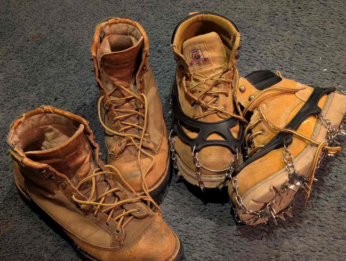
After experiencing several falls on ice last year, I decided to take preventative measures and attached ice cleats (cranpons)to my boots. I have been using them consistently over the past few days while navigating my icy driveway, and I have found them to be very effective, providing me with significantly enhanced confidence when gripping snow and ice. While the added traction has been invaluable, the one drawback is the potential for damage to indoor surfaces. Specifically, wearing these cleats indoors poses a risk to carpets and vinyl floors.
Leave a Reply
You must be logged in to post a comment.